Grand Canyon, Petrified Forest, Saguaro NPs, Oct-2025

Oct 20 - 26, 2025
Monday, Oct 20
☀ Weather: Good travel weather
🛪 Travel Day
O'hare - Phoenix. Flight was delayed an hour and arrived in Phoenix at 1:30, SIXT car rental (chevy Traverse) and headed 2 hours North to our Airbnb in the town of Williams (an hour South of Grand Canyon's South Rim). On our way we stopped in Flagstaff and had dinner at Phillip's Bar and Grill.
The airbnb was fantastic. Newly remodeled, 2 beds, 3 baths, spacious, clean, comfortable and an amazing dark sky to view the stars!


Tuesday, Oct 21
☀ Weather: 70s sunny.
Drove ~1 hour to Grand Canyon National Park. Due to the government shutdown the visitor center was closed but, everything else (shuttle buses, bathrooms, bookstore) were open.
Stopped at the bookstore for tees, hats and hoodies.
About Grand Canyon National Park
Geography
Park Size:
1,218,375 acres (493,059 ha)
1,904 square miles (4,931 km2)
Length: 278 river miles (447 km)
Width:
Minimum at Marble Canyon, 600 feet (180 m)
Average Rim to Rim, 10 miles (16 km)
Maximum Rim to Rim, 18 miles (28.8 km)
Depth: Average, 1 mile (1.6 km)
Elevations:
South Rim 7,000 feet (2,100 m)
North Rim 8,000 feet (2,400 m)
Volume: 5.45 trillion cubic yards (4.17 trillion m3)
Colorado River in Grand Canyon National Park
Length: 278 miles (447 km)
Average Width: 300 feet (90 m)
Minimum Width: 76 feet (23 m)
Average Depth: 40 feet (12 m)
Greatest Depth: 85 feet (25.5 m)
Average Gradient: 7 feet per mile (1.3 m/km)
Elevation at Phantom Ranch: 2,400 feet (720 m)
The Colorado River is 1,450 miles (2,333 km) long from its source in the Rocky Mountains of Colorado to the Gulf of California.
Geology: Grand Canyon National Park preserves an iconic geologic landscape and resources ranging from 1.8 billion (PreCambrian) year-old igneous and metamorphic rocks to 230 million (Triassic)-year-old sedimentary rocks, 5 million (Pliocene)-year old to recent volcanic deposits, a complex tectonic and erosional history, and unconsolidated surface deposits.
The Colorado River established its course through the canyon approximately 6 million years ago and likely evolved from pre-existing drainages to its current course. Geologic processes, including erosion of tributaries and slopes, and active tectonics continue to shape the canyon today. The geologic record in Grand Canyon is an important scientific chronicle and is largely responsible for its inspirational scenery.
Palentology resources include nearly 300 diverse and globally significant fossil localities ranging from 1.2-billion-year-old stromatolites to Paleozoic trilobites, plants, reptile tracks, and marine invertebrates, and Pleistocene megafauna in caves.
You can learn more about the geology here: Geology in Grand Canyon National Park.
You can learn more about the park here: Grand Canyon National Park.


Hike: Mather Point - Bright Angel
Our first hike was along the South Rim from Mather Point to Bright Angel trail head. Our first views of the Canyon were incredible. Along the trail we stopped at the Geology Museum at Yavapi point and learned about all the different rocks that make up the many layers uncovered by the Grand Canyon. The views were so spectacular we couldn't help stopping every few feet for more pictures. Along the trail they also had the "Walk of Time" and many rock displays. The park gets 5 million visitors a year so we were expecting large crowds but were pleasantly surprised the popular hike was not crowded at all. Nice!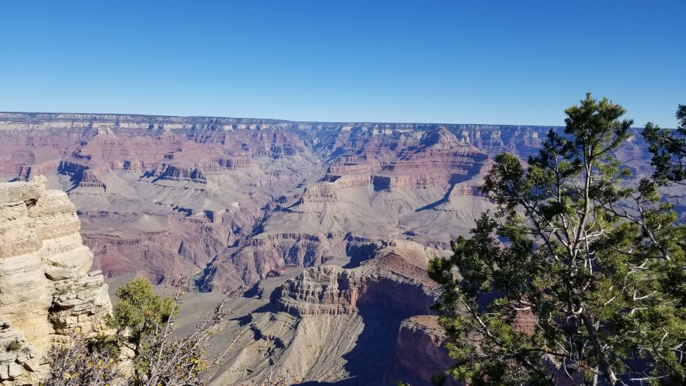


 VIDEO
VIDEO  VIDEO
VIDEO 


 VIDEO
VIDEO 


 VIDEO
VIDEO 
 VIDEO
VIDEO 


Grand Canyon Shuttle System
The main drive around the southern rim is restricted to the shuttles so you park in the vast parking lot at the visitor center (limited parking also in the Village) and you take the shuttle to the trail heads. There are blue, red and orange lines. It is nice that you can hike point-point and shuttle back.
Lunch and Afternoon Hike - Mather Point to South Kaibob Trail Head
After our hike we took the blue shuttle line back to the visitor center parking lot and had lunch on a picnic table near our car.
Our afternoon hike again started at Mather Point near the visitor center but we went East this time again along the rim out to the Kaibob trail head. This hike was even less crowded than the morning hike and we saw lots of Elk along the trail (although difficult to capture on film). Very cool! Another really nice hike. After the hike we took the Orange shuttle back to the visitor center and drove back to Williams for our 2nd night in the bnb.


Wednesday, Oct 22
🌤 Weather: 70, overcast.
Since parking was not an issue and we planned to stay for sunset in the park we had a relaxing morning at the bnb before heading back to the park.
Hike - Trail View Overlook to Maricopa Point, then Hermits Rest to Powell Point
Took the blue shuttle back to the village and the transfer point to the red shuttle. Hopped on the red shuttle and at the first stop we got off to take pictures thinking the shuttle stayed a couple of minutes. Well..it didn't so instead of just waitng for the next shuttle we hiked the trail to Maricopa Point and then grabbed the shuttle to take us to the end of the line at Hermit's Rest. We hiked from Hermits Rest back to Powell Point stopping along the way for lunch right along the rim. Barely anyone on the trail today. Nice.
Not far from Hermit's Rest the dirt trail got within a foot of the cliff with no railing, I'm guessing a 600' drop. A little sketchy to be sure, we watched our steps very carefully. This lasted about a quarter mile and the rest of the trail had a few feet buffer from the cliff and/or a safety railing, thank goodness! When we stopped for lunch we could see the section of the trail we had been on that was right along the cliff edge and saw the devastating drop, zoiks!
The cloud cover created lots of interesting shadows and colors in the canyon giving it a different look than yesterday.


 VIDEO
VIDEO 


 VIDEO
VIDEO 


Sunset at Mather Point
After the hike we caught the red line and then the blue line bringing us back to the parking lot. It was already late afternoon so we headed back to Mather Point to watch the sunset. This time of year the sunset itself was blocked by the cliffs but, still created lots of colors in the canyon as the sun set.


 VIDEO
VIDEO 


After the sunset we said goodbye to the Grand Canyon and went back to our last night staying at the bnb in Williams.
Thursday, Oct 23
☀ Weather: 70s, sunny!
Meteor Crater
Petrified Forest National Park is about 2 1/2 hours East of Williams and about halfway along the way is the site of Meteor Crater.
Over 50,000 years ago space and earth came together when a huge iron-nickel meteorite, approximately 150 feet wide and weighing several hundred thousand tons, impacted an area outside of Flagstaff, Arizona, with a force 150 times greater than an atomic bomb. The result of this impact was devastation for miles and the creation of the giant bowl-shaped cavity we call Meteor Crater, which measures 550 feet deep and almost a mile wide. You can read more about it here: Meteor Crater
It is one of the most well preserved impact craters in the world due to Arizona's dry and stable climate. Amazing to see the size hole a 150' meteor created. It wasn't a destination of it's own but, since it was on the way to Petrified Forest it was worth the stop. There was a small museum a guided tour and a short movie. Note: the first image is just the largest fragment found, most of the meteor dissintegrated on impact.


 VIDEO
VIDEO 


About Petrified Forest National Park
Petrified Forest is a surprising place, offering far more than the world renowned petrified logs. You can see so much just from your car and a few stops at overlooks. Imagine what you can see by walking one of the short maintained trails or even hiking into the backcountry along one of the Off the Beaten Path routes! There are fossils, badlands, buttes and mesas, ancient petroglyphs, wildlife and wildflowers, and vast vistas for more than a hundred miles! If you are craving some quiet solitude, the Painted Desert is perfect for hiking and contemplation. You can learn more about the park here: Petrified Forest NP
Petrified Forest National Park
When we google mapped the route from Williams to Meteor Crater to Petrified Forest's first planned trail head Google warned us that the Park Road was closed. Arg! About a week ago the park had still been open (according to the web site) but now it looked closed. The park has a North and South entrance and everything in the park is along the Park Road. We decided to make the trek and see for ourselves. Sure enough, the gate was locked and there was a park truck parked inside watching for any trespassers. Here is all we got!


Holbrook, AZ - Petrified Wood
We hung out in the parking lot outside the park and ate our lunch in the car, I was bummed, oh well. We drove to the small town ofHolbrook about 20 mintues from the park where we are staying the night. For dinner we went to a quaint diner, Bienvenidos, and had some good comfort food. As consolation, I took pictures of the petrified wood outside the diner and outside our hotel. Best we could do.


Friday, Oct 24
☀ Weather: 80, Sunny!
A long drive ahead of us (5 hours, 250 miles). Saguaro National Park has an East and West section with the city of Tucson in between. Thus, it is described as an urban park. The drive was not what we had expected, instead of flat desert land, it was traversing green mountain pass after mountain pass. A lot prettier than we anticipated. Unfortunately, when we got to the out skirts of Tucson the traffic was pretty terrible. Eventually, we made it to our trail head in the Eastern section of the park. Fortunately, the park has lots of roads into the various sections of the park and these were open and accessible! So, hiking we go!
About Saguaro National Park
Tucson, Arizona is home to the nation's largest cacti. The giant saguaro is the universal symbol of the American west. These majestic plants, found only in a small portion of the United States, are protected by Saguaro National Park, to the east and west of the modern city of Tucson. Here you have a chance to see these enormous cacti, silhouetted by the beauty of a magnificent desert sunset. You can read more about the park here: Saguaro NP.
Mica Trail
The saguaro is a columnar cactus that grows notable branches, usually referred to as arms. Over 50 arms may grow on one plant, with one specimen having 78 arms.[7] Saguaros grow from 3–16 m (10–52 ft) tall, and up to 75 cm (30 in) in diameter. They are slow growing, and routinely live 150 to 200 years. They are the largest cactus in the United States.[wikipedia].
The hike was easy meandering through all the Cactus. We counted 16 arms on one tall cactus and I assumed it was the oldest we saw. A nice hike and only a couple of other hikers.


 VIDEO
VIDEO 


Saturday, Oct 25
☀ Weather: mid 80s, sunny, warm.
Thunderbird Trail
We headed to the West section of Saguaro National Park but had a little difficulty finding the trail head. All trails has always gotten us to the trail head over the years but this time the directions took us to a lousy part of Tucson. Trying again from all trails we got closer to but again was not near the trail head. The third time, still using All Trails, it finally got us to the trail head. Crazy!
The hike was nice with some elevation gain. Only saw one other party on the trail. Nice!


 VIDEO
VIDEO 
Sunday, Oct 26
☀ Weather: Good travel weather here and in Chicago.
🛪 Travel Day
We had an early 7:05 am flight out of Tucson so we left our Airbnb at 4:40a just in case we ran into any delays. And....we did! On the way to the airport the police had closed the main road we needed to take to get to the airport (not sure why). There were no other major roads to get around the closure and helpless to google maps, it kept directing us back to the same closed road. After our third stop back at the closure we got out and asked how to get to the airport. The worker gave us the directions to avoid the closure and we eventually made our way to the airport luckily with plenty of time to catch our flight.
A short flight to Phoenix and then the longer flight from Phoenix to O'hare. The flights were on time and uneventful.
Home Sweet Home.
Summary
- ✅Grand Canyon National Park- Breathtaking, it is in our top 10 parks visited.
- ✅Meteor Crater- Cool. Not worth it as a sole destination but a nice stop since it was on the way from Grand Canyon to Petrified Forest.
- ✅Petrified Forest National Park- Well, hard to say as the gates were closed.
- ✅Saguaro National Park- Some nice hiking in the Sonoran desert. The Saguaro Cactus are very cool.
- ✅Tucson- Did not spend enough time to get a good impression.